
Lafayette Parish Postal Coverage
The working ZIP code directory combines Louisiana's official community list, USPS destination groups, Census city ZCTAs, and a USPS facility record. Each row says only what its source supports. A destination grouping is not proof that the whole code lies in Lafayette Parish, and a Census overlap is not a delivery boundary.
| ZIP | Area clue | Post office or group | Evidence note |
|---|---|---|---|
| 70501 | Lafayette | Lafayette 70501 group | State community list and Lafayette facility. |
| 70502, 70503, 70505, 70506 | Lafayette destinations | Lafayette 70503 group | USPS grouping; 70503 and 70506 also overlap the Census city. |
| 70507, 70509 | Lafayette destinations | Lafayette 70501 group | 70507 also appears in the Census city ZCTA set. |
| 70508 | Lafayette / Carencro group | Carencro 70520 group | Census city overlap does not define a parish line. |
| 70515, 70532, 70535, 70542, 70548, 70598 | Carencro destination group | Carencro 70520 group | Address-level USPS check required. |
| 70518 | Broussard | Lafayette 70501 group | Community name and postal grouping describe different layers. |
| 70520 | Carencro | Carencro 70520 | State list and USPS group agree on the locality. |
| 70529 | Duson | Duson | Acadia / Lafayette parish edge needs a parcel check. |
| 70558 | Milton | Milton | State community list. |
| 70583 | Scott | Scott | State list and Census city overlap. |
| 70592 | Youngsville | Lafayette 70501 group | State list, USPS group, and Census city overlap. |
| 70528, 70533, 70577, 70589, 70596 | Lafayette destinations | Lafayette 70503 group | DMM group only in the reviewed evidence. |
The roster intentionally does not assign 70504, 70517, or 70578 from memory. No reviewed static source confirmed them as parish-serving codes. It also treats 70555 as nearby Maurice, not Lafayette Parish, until a full address is checked. That restraint is central to a useful Lafayette Parish ZIP code directory.
A Lafayette ZIP Is Postal
USPS created ZIPs to route mail. They are not legal municipality, parish, council, court, tax, or school boundaries. A Lafayette mailing city may describe a delivery convention even when the land lies in an unincorporated parish area or another municipality. Broussard and Youngsville codes can also sit in Lafayette destination groups without becoming City of Lafayette territory.
This is the key myth to discard before a resident search. Use a ZIP code to narrow candidates, then establish the parcel and civil jurisdiction with LCG GIS and the Assessor. Court and public-record requests must go to the office with authority over the actual location, not the postal name alone.
Find Lafayette Residents by ZIP
Two official paths use postal data in a practical way. USPS validates the delivery line. The Louisiana voter portal accepts ZIP as part of both its name and address workflows. Neither route should be treated as a free-standing parish-wide resident list.
- Enter the complete street, unit, city, and state in the official USPS lookup. Save the standardized result and ZIP+4.
- Run the voter address screen with ZIP, street address, apartment or lot, and city. Protected records and statutory exclusions can limit the result.
- Use LCG GIS to identify the address point, parcel situs, and legal municipality. Do not substitute a Census ZCTA outline for this step.
- Compare the Assessor's parcel fields and mailing address. The basic tax search did not expose a ZIP filter, so search by parcel or address through Beacon/GIS.
- If requesting a voter list, contact the Registrar of Voters for the lawful list process, field availability, advance estimate, and current format.
Once the postal area narrows to a named road, the Lafayette Parish street directory owns the parcel-to-deed chain. The ZIP page stays at postal granularity and does not presume that everyone sharing a code shares a city, district, or community.
Lafayette ZIP Search Fields
The Louisiana Secretary of State voter portal offers a name screen and an address screen. The name route uses ZIP to narrow a person, while the address route places ZIP before street, unit, and city. Live result columns were not exposed during research, so the fields below describe the search contract rather than promise a result schema.
| Screen | Field order | Format | Purpose or limit |
|---|---|---|---|
| Name lookup | First Name | Text | Use with another identifier. |
| Name lookup | Last Name | Text | Common names need more detail. |
| Name lookup | ZIP Code | Text | Narrows the postal area, not civil jurisdiction. |
| Name lookup | Birth Month/Year | mm/yyyy | Partial date discriminator; full birth date is not shown. |
| Address lookup | ZIP, Address, Apt/Lot, City | Text plus city selection | Can search a voter address, subject to privacy controls. |
The portal disclaimer says the connection is encrypted and excludes Social Security number, email, full birth date, mother's maiden name, and assistance-entitlement information from public display. It also notes protected-record limits and session timeout.
The manifest image shows the official ZIP-capable voter address lookup.
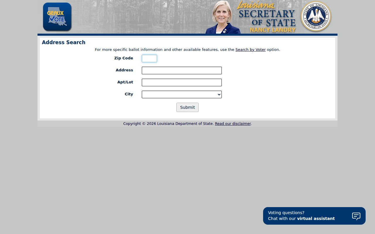
The screen confirms why a ZIP belongs beside the street and city fields, not in place of them.
Verify Lafayette Postal Addresses
The USPS ZIP Code by Address tool asks for company, street address, apartment or suite, city, state, and ZIP before returning a standardized postal result. Use it when a code is missing, disputed, or attached to a mailing city that does not match the legal municipality.
The successful ZIP manifest capture preserves that official form.
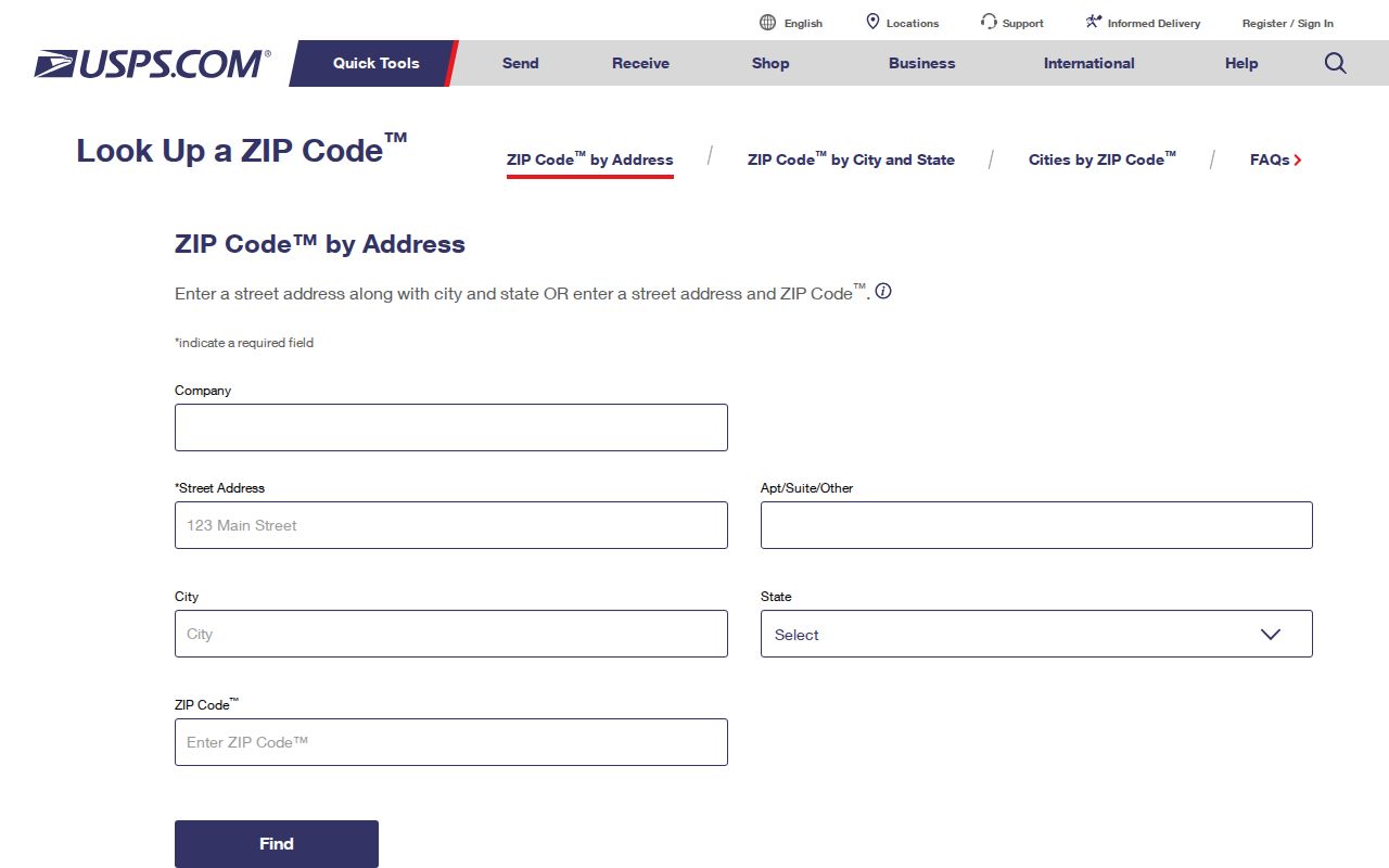
Its full-address fields reinforce the right order: validate the delivery line first, then consult Lafayette Parish GIS and property records for civil geography.
The Lafayette Post Office facility record lists 1105 Moss Street, Lafayette, LA 70501-9998 and 337-269-7110. Facility details can change, so use the USPS page for current service information rather than infer service from a destination group.
Lafayette ZCTAs Are Different
The Census Bureau builds ZIP Code Tabulation Areas, or ZCTAs, as statistical approximations from address data. They can be noncontiguous and do not replace USPS delivery definitions. Lafayette city's Census profile includes full or partial overlaps with 70501, 70503, 70506, 70507, 70508, 70518, 70583, and 70592.
Those overlaps are useful for Census statistics, but they do not prove that a ZIP serves all of the city or parish. A ZIP code directory must label ZCTA evidence as statistical. Use USPS for delivery and LCG for a parcel's civil location.
Lafayette ZIP and City Limits
Postal areas and Lafayette Parish civil lines answer different questions. The code routes mail. The municipality determines some local jurisdiction. The parish sets another layer, while precinct, council, school, and court boundaries may differ again. A record should carry the mailing city and legal municipality as separate fields.
- ZIP and ZIP+4
- The five-digit delivery area plus four digits that narrow the destination to a smaller delivery segment.
- PO-box ZIP
- A postal code used for box delivery rather than a general street-delivery area.
- Unique ZIP
- A code assigned to one high-volume organization. No Lafayette Parish unique ZIP was verified in the reviewed sources.
- Carrier route
- A group of addresses served by a postal carrier route; it is still not a civil boundary.
At the Duson edge, parish context is especially important. The official state list notes Acadia and Lafayette context, so a Duson mailing label alone cannot assign the parcel. The same caution applies to the nearby Maurice code, which remains outside the working parish roster without address-level proof.
Keep Four Lafayette Address Forms
A robust ZIP directory note keeps four identities when they differ: USPS mailing line, LCG address point, Assessor parcel situs, and Clerk legal description. Add the date of the search. The Assessor's mailing-change form demonstrates why the mailing address and property address must not be merged.
For a disputed result, preserve the USPS standardized ZIP+4, then compare the GIS point and municipality, parcel fields, voter address input, and deed description. The tax search offers an address route but no visible ZIP filter in the captured fields. A missing ZIP search option is not proof that the address lies outside the parish.
Lafayette ZIP Lookup Fallbacks
When a portal fails, use the access channel that holds the needed fact. USPS can verify the postal line online or through its facility tools. LCG GIS accepts map questions and custom map requests through its official maps office. The Assessor can explain parcel and mailing fields, while the Registrar of Voters handles protected-record questions and lawful list requests. Louisiana Public Records Law, La. R.S. 44:1 et seq., supplies the general request framework for LCG records through JustFOIA, subject to specific exemptions.
A mailed or in-person request should state the full address, ZIP, municipality sought, record type, and date range. Ask for an existing record, not an agency conclusion about where someone lives. If the question is historical, library maps, directories, and newspapers may preserve an older postal or place label that no current ZIP tool recognizes.