
Walk a Lafayette Parish Street
A sound street search moves from geography to names. Start with the exact number, unit, street spelling, municipality, ZIP, and date. The LCG Maps and GIS page links street maps and interactive tools showing roads, address points, municipalities, districts, rail lines, and waterways. These layers place an address before any name is attached.
- Standardize the full address. Save old spellings, directionals, unit or lot number, mailing city, and approximate date separately.
- Locate the address point and parcel in LCG GIS or Beacon. Copy the assessment number, situs, legal description, subdivision, and displayed ownership.
- Verify the latest owner in the Lafayette Parish Clerk conveyance index. Follow prior-act, book/page, plat, and legal-description references.
- Check the Louisiana voter address search with ZIP, street, unit or lot, and city. Treat a result as a current registration clue.
- For an older date, use directories, newspapers, permits, plats, or the 1906 Sanborn sheets, then confirm each name in a second dated source.
This Lafayette Parish street directory chain separates a parcel from people linked to it at different times. An assessor name is not a household list. A voter result is not title evidence. The deed is the legal transfer record, while a directory entry remains a dated clue.
Read Lafayette Parish Parcel Terms
Four terms prevent the most common by-address error: treating the tax-mail destination as the land location. The Assessor's AC-01 form separates property address or description from mailing address, care-of line, city, state, and ZIP+4.
- Parcel
- A mapped unit of land tied to an assessment number. A parcel map gives context, but it is not a legal survey.
- Situs address
- The street location assigned to the property itself, distinct from where a tax bill is mailed.
- Plat
- A recorded drawing of lots, blocks, streets, and subdivisions. Some Clerk entries refer users to a plat filing cabinet.
- Criss-cross directory
- A directory arranged by street or address, used for dated occupant clues rather than current legal ownership.
The Lafayette Parish Assessor search directs real-estate users to an assessment-number route. Its visible owner-name field is for business personal property. Real-estate name, address, and parcel discovery routes through the linked Beacon/GIS application.
Lafayette Street Search Fields
The assessor and map systems serve different roles in the street directory. The basic screen works once an account number is known. Beacon's public results exposed parcel, alternate ID, address, ownership, city, area, state, assessed value, reference number, and STR columns, though its live map controls were blocked during research.
| Field or control | Type | Required | Street use |
|---|---|---|---|
| Assessment Number instruction | Static text | N/A | Points real-estate searches to the parcel identifier. |
| Account Number | Text | No | Retrieves the matching assessment route. |
| Business Owner Name | Text | No | Searches business personal property only. |
| Search / Clear | Buttons | N/A | Submits or resets the form. |
| Name / address / parcel | GIS search | Not exposed | Beacon route for real-estate discovery. |
For a whole street, pan along the official map and record each parcel ID rather than assume there is a complete export. Save the map date and layer name. Compare every situs with the mailing field and legal description.
Lafayette Parish By-Street Records
No one Lafayette Parish roll answers every address question. Pair current map and assessment fields with the Clerk's legal instruments, then add dated voter, permit, directory, or newspaper evidence only for the fact each can support.
| Record set | Street key | What it shows | Main limit |
|---|---|---|---|
| LCG address points | Number, name, segment | Current formatted address and road context | Older change needs a dated source. |
| Assessor / Beacon | Situs or parcel | Displayed owner, value, exemptions, mailing split | Display is not the recorded deed. |
| Clerk deeds and plats | Legal description, lot, act | Recorded parties, transfers, subdivision chain | Subscription and dates vary. |
| MGO planning records | Project address | Permits, inspections, zoning and code actions | Exact fields and history were not exposed. |
| Voter address search | ZIP, street, unit, city | Public registration clues | Protected-record rules apply. |
| Directories / Sanborn | Street, block, year | Past occupants and building context | Dated, incomplete coverage. |
Utility customer lists, delivery records, and private household rosters are not part of this verified chain. Each source establishes a distinct fact. Combining names requires dates and labels, not a guess that all people shown at one parcel lived together.
Follow Lafayette Parish Street Deeds
The Lafayette Parish Clerk of Court records conveyances, mortgages, cancellations, plats, UCC filings, and related instruments. Begin with the GIS legal description and assessment number. Search vendor and vendee entries, Louisiana terms for seller and buyer, then inspect the newest instrument and its prior-deed citations. Mortgage and cancellation indexes supply separate lien and release evidence.
Online land images begin in January 1935, while category starts differ. When web coverage ends, use the Clerk's physical index, deed book, plat cabinet, or written copy request. The current-through date shows indexing progress, not complete image release.
The manifest capture opens the Clerk land eSearch access point.
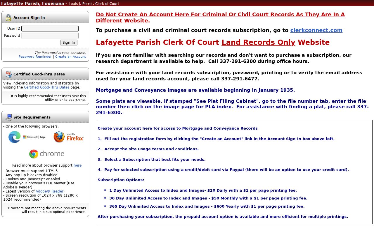
The login screen marks the access boundary: the index is the deed-chain gateway, while post-login controls and images may require an account or charge.
Lafayette Addresses in MGO
Development & Planning routes current permit, planning, code-enforcement, and inspection work through LCG building and renovating resources and MGO Connect. Published routes include residential and commercial permits, occupancy certificates, annexations, abandonments, address certificates, plats, rezonings, conditional uses, and zoning verification.
The portal shell displayed only a loading state, so its fields, date span, attachments, status tabs, and exports need live confirmation. An old CPR packet names permit number, project address, proposed use, prior use, and scope, but eTrakit is not current. Use a permit to date property work, not to infer who lived there.
Lafayette Streets Across Time
Lafayette was incorporated as Vermillionville in 1836 and renamed Lafayette in 1884. Old newspapers, deeds, church entries, and place references may use that earlier name. Parish boundaries also changed, so date and place belong together in every street-directory note.
The 1906 Lafayette Sanborn map set has six sheets of block and building context. LCG guidance warns that square numbers can change and not all areas appear. Search by bounding streets and year, then tie the old footprint to a current parcel and legal description. No official renumbering year was found, so test a suspected change across directories, plats, maps, permits, and address certificates.
For full historical holdings, use the Lafayette Parish city directories. This street directory uses those volumes only as one dated layer in the address chain.
Lafayette Streets Cross Jurisdictions
Lafayette Parish includes Broussard, Carencro, Lafayette, Scott, Youngsville, Duson, and unincorporated Milton. A postal line saying Lafayette can still fall outside the City of Lafayette. City court, code, parish government, tax, and planning coverage cannot be inferred from the mailing city.
Check the legal municipality on the parcel and match the agency's jurisdiction. USPS validates delivery, while GIS, the assessor card, and the legal instrument locate the land. A ZIP narrows a street search but cannot settle the government boundary.
Current Lafayette Address Updates
LCG's 2025 annual report lists 2,664 address points, more than 350 road centerlines, 259 subdivisions, 2,589 lots, 12 annexation updates, and 55 zoning updates. It also reports more than 300 GIS requests and 120 maintained maps and apps. Current address geography is a live record layer.
An old directory can be accurate for its date even if its street line fails today. Keep both forms. A new centerline or address-point edit explains the modern search, while a deed description or historic map carries the location backward.
Lafayette Street Tax Clues
The Lafayette Parish Sheriff's tax portal adds a dated billing layer to the street directory. Its choices include notice or bill number, parcel, taxpayer name, address, and tax year. Capture the selected year, parcel or bill identifier, legal description, taxpayer label, and payment or adjudication status. A taxpayer name is not the same as deed ownership. Bills can use a separate mailing address, and an entity may pay tax for land used by someone else.
Municipal billing history also varies by place and year. The Sheriff's research page points to the Tax Department at 1010 Lafayette Street, fourth floor, and 337-236-5880 when the public portal does not settle the question. An adjudicated-property listing is a sale or status clue, not proof of today's owner. Confirm the land and transfer through the assessor parcel and Clerk conveyance record.
Tax data works best as a dated checkpoint between assessment and deed evidence. Keep the tax year visible. A current bill cannot by itself establish who occupied the address in that year.
Lafayette Street Voter Checks
The Louisiana voter address screen accepts ZIP Code, Address, Apt/Lot, and City. It can return a public voter clue at an address, but the portal's disclaimer and Louisiana law govern what may appear. Full birth date, Social Security number, email, mother's maiden name, and assistance details are not shown. Address Confidentiality Program participants and other protected voters may have data withheld or substituted.
For a list request or a record the public screen cannot resolve, contact the Lafayette Registrar of Voters at 1010 Lafayette Street, Suite 313, Lafayette, or 337-291-7140. The published list process uses an advance estimate and payment, and available fields remain subject to statutory exclusions. A vote-participation date does not disclose a ballot choice.
Use the voter source after the parcel has been fixed, not before. Matching a street and ZIP still does not prove a person occupies the parcel today. Compare the name with another dated public record and record the lookup date.
Limits of Lafayette Street Records
A Lafayette Parish street directory cannot identify every resident. Occupants who do not hold title may not appear on the property roll. A parcel can be held by an entity, estate, or absent owner. Assessment data may lag a deed, and tax mail may go elsewhere. Voter data omits confidential fields and can suppress or substitute an address under Louisiana protection laws.
Directories skip years, areas, and people. Sanborn maps show buildings, not title. Permit and code files describe property action, not private conduct. Check each address result against another dated source.
Lawful use. Use Lafayette Parish address records only for lawful personal research. Never use a street search to stalk, harass, threaten, or harm anyone.